Science
Norwegian Scientists Launch SmartNav to Revolutionize Urban GPS
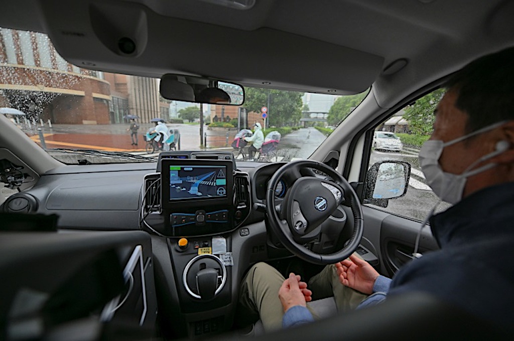
Scientists from the Norwegian University of Science and Technology have introduced a groundbreaking technology called SmartNav, designed to enhance GPS functionality in urban environments. This innovative system combines satellite data and Google’s city mapping capabilities to tackle the persistent challenges faced by traditional GPS in densely populated areas.
Standard GPS technology struggles in what are known as “urban canyons,” where tall buildings and reflective surfaces disrupt satellite signals. In these environments, GPS receivers often receive delayed signals, leading to inaccuracies in location tracking. According to Ardeshir Mohamadi, the lead researcher on the project, “In cities, glass and concrete make satellite signals bounce back and forth. Tall buildings block the view, and what works perfectly on an open motorway is not so good when you enter a built-up area.”
Understanding the Limitations of Traditional GPS
The Global Positioning System (GPS) relies on a network of satellites that transmit signals to receivers on Earth. These signals contain information about the satellite’s location and the precise time the signal was sent. For a GPS receiver to determine its location accurately, it needs signals from at least four satellites. However, in urban settings, the signals can reflect off buildings, creating multiple paths that delay their arrival. This reflection not only confuses the receiver but also reduces the precision of the reported position.
The limitations of traditional GPS have significant implications, particularly for autonomous vehicles. As these vehicles become more prevalent, the need for accurate navigation systems that function reliably in urban areas is critical.
SmartNav: A Multifaceted Solution
To address these challenges, the researchers developed SmartNav, which integrates several advanced technologies to improve signal accuracy. The system employs a combination of satellite corrections, wave analysis, and Google’s 3D building data. During testing, SmartNav achieved an impressive accuracy of within 10 centimetres, a feat that could greatly enhance the navigation capabilities of future autonomous vehicles.
The technology’s success hinges on the integration of multiple approaches. The first involves analyzing the carrier phase of radio waves rather than just the GPS code. By examining whether the wave travels upwards or downwards when it reaches the receiver, researchers can achieve higher accuracy, albeit at a slower speed.
Another component of SmartNav is Real Time Kinetics (RTK), which uses a series of base stations to provide real-time corrections to GPS signals. This method is particularly effective in areas where users are within proximity to these stations. Additionally, the system utilizes Precise Point Positioning – Real-Time Kinematic (PPP-RTK) techniques that combine satellite data with precise corrections, a capability now supported by the European Galileo system.
Finally, Google contributes to the project by providing 3D models of buildings in nearly 4,000 cities worldwide. These models are crucial for predicting how satellite signals will bounce off urban structures, allowing for more accurate navigation.
The combination of these technologies marks a significant advancement over conventional GPS systems. The researchers aim for SmartNav to facilitate reliable urban navigation, creating platforms that are both accessible and affordable on a global scale.
The findings related to this innovative technology are detailed in the Journal of Spatial Science, with a paper titled “Phase-Only positioning in urban environments: assessing its potential for mass-market GNSS receivers.” A follow-up study, “FLP-Aided GNSS RTK Positioning: A Means of Supporting Smartphone High-Precision Positioning in Dynamic Urban Environments,” is set to be published in the Journal of the Institute of Navigation within the next month.
The introduction of SmartNav could revolutionize how GPS operates in urban settings, paving the way for advancements in autonomous technology and enhancing navigation accuracy for users across the globe.

Canadian Officer Sues India Over False Terrorism Allegations
Sauk Valley Community College’s Impact Program Transforms Lives

EngineAI Unveils Revolutionary T800 Humanoid Robot in New York

Morris Hospital Honors Julie Robbins as November Fire Starter

India Mandates Pre-Installation of Government App on Smartphones
Chronic Pain Report Aims to Transform Care for Women

RCMP Limits Use of Chinese-Made Drones Over Security Concerns

Indiana University’s Jewish Studies Program Faces Controversy

Vestas Boosts Production in Poland for Germany’s Wind Energy Surge

Toyoake City Proposes Daily Two-Hour Smartphone Use Limit

B.C. Review Reveals Urgent Need for Rare-Disease Drug Reforms

Pedestrian Fatally Injured in Esquimalt Collision on August 14

Dark Adventure Game “Bye Sweet Carole” Set for October Release

Jimmy Lai’s Defense Challenges Charges Under National Security Law

Victoria’s Pop-Up Shop Shines Light on B.C.’s Wolf Cull

Konami Revives Iconic Metal Gear Solid Delta Ahead of Release

Apple Expands Self-Service Repair Program to Canada

Snapmaker U1 Color 3D Printer Redefines Speed and Sustainability
-
 Science3 months ago
Toyoake City Proposes Daily Two-Hour Smartphone Use Limit
-
 Health4 months ago
B.C. Review Reveals Urgent Need for Rare-Disease Drug Reforms
-
 Top Stories4 months ago
Pedestrian Fatally Injured in Esquimalt Collision on August 14
-
 Technology3 months ago
Dark Adventure Game “Bye Sweet Carole” Set for October Release
-
 World3 months ago
Jimmy Lai’s Defense Challenges Charges Under National Security Law
-
 Lifestyle4 months ago
Victoria’s Pop-Up Shop Shines Light on B.C.’s Wolf Cull
-
 Technology3 months ago
Konami Revives Iconic Metal Gear Solid Delta Ahead of Release
-
 Technology3 months ago
Apple Expands Self-Service Repair Program to Canada
-
 Technology3 months ago
Snapmaker U1 Color 3D Printer Redefines Speed and Sustainability
-

 Technology3 months ago
AION Folding Knife: Redefining EDC Design with Premium Materials
-

 Technology4 months ago
Solve Today’s Wordle Challenge: Hints and Answer for August 19
-
 Business4 months ago
Gordon Murray Automotive Unveils S1 LM and Le Mans GTR at Monterey