
Top Stories
Snow Squall Warnings Issued for Toronto and GTA, Hazardous Travel Expected

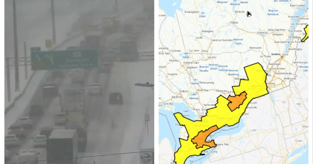
A snow squall warning has been issued for Toronto and surrounding regions within the Greater Toronto Area (GTA), with Environment Canada predicting “brief but intense” snowfall that could lead to hazardous travel conditions this afternoon. The advisory specifies that areas including Peel, York, Durham, and Halton are likely to experience difficult driving conditions due to reduced visibility and high winds.
The national weather agency estimates that Toronto may see between four and six centimetres of snowfall. However, gusty winds reaching up to 70 km/h will create blowing snow, further complicating travel. Environment Canada warns that visibility could be drastically reduced to near zero at times, resulting in significant impacts on rush hour traffic.
Conditions Across the Region
Areas north of the GTA, such as Caledon, Aurora, and Orangeville, as well as communities to the east like Port Hope and Cobourg, could receive much heavier snowfall, with totals potentially reaching up to 25 centimetres during the storm. Additionally, parts of the Niagara Region have been placed under a snow squall warning, with expected accumulations of 30 centimetres in locations including Welland, Fort Erie, Port Colborne, and Niagara Falls.
As a precaution, several school boards in the Niagara Region have canceled bus services in response to the inclement weather. Reports from the Ontario Provincial Police indicate that whiteout conditions were already present in the area on Monday morning, making travel dangerous.
Cold Snap Expected in Toronto
While Toronto is not anticipated to experience the heaviest snowfall, a significant cold snap is set to affect the city this week. Temperatures are expected to peak at -6 degrees Celsius on Monday, but the wind chill will make it feel closer to -17 degrees Celsius. Overnight, temperatures will drop further to -15 degrees Celsius, feeling like -25 degrees Celsius with the wind chill.
On Tuesday, temperatures will reach a high of -9 degrees Celsius, and wind chill values will create a perceived temperature of -26 degrees Celsius in the morning and -19 degrees Celsius in the afternoon. The situation will improve slightly on Wednesday, with temperatures expected to rise to 0 degrees Celsius, but cold weather will return by Thursday, when highs are projected at -4 degrees Celsius.
To support residents during the extreme cold, the City of Toronto will open additional warming centres at 5 p.m. on Monday. Locations include the Cecil Community Centre, situated at 58 Cecil Street, and the Jimmie Simpson Recreation Centre, located at 870 Queen Street East. Existing warming centres will also remain open to provide refuge from the frigid temperatures.
As the weather develops, residents are advised to stay informed about road conditions and to adjust their travel plans accordingly.

Meta Plans Major Layoffs as AI Costs Surge

Alberta’s Referendum Could Pave Way for U.S. Statehood

Minooka District 201 Plans Enhanced Bilingual Support for Students

Canmore Approves Multiple Development Permits for New Projects

Remembering Bradly Castillo Shearsmith: A Life of Friendship and Joy

BIS Urges Watchdogs to Integrate Synthetic Risk Transfers in Stress Tests

Teva Transforms: Shifting Focus from Generics to Branded Success

Apple Launches AirPods Max 2 with Enhanced Audio Features

Ontario Ends Funding for Seven Supervised Injection Sites

Toyoake City Proposes Daily Two-Hour Smartphone Use Limit

Pedestrian Fatally Injured in Esquimalt Collision on August 14

B.C. Review Reveals Urgent Need for Rare-Disease Drug Reforms

Dark Adventure Game “Bye Sweet Carole” Set for October Release

Konami Revives Iconic Metal Gear Solid Delta Ahead of Release

Jimmy Lai’s Defense Challenges Charges Under National Security Law

Victoria’s Pop-Up Shop Shines Light on B.C.’s Wolf Cull

Snapmaker U1 Color 3D Printer Redefines Speed and Sustainability

Apple Expands Self-Service Repair Program to Canada
-
 Science11 months ago
Toyoake City Proposes Daily Two-Hour Smartphone Use Limit
-
 Top Stories11 months ago
Pedestrian Fatally Injured in Esquimalt Collision on August 14
-
 Health11 months ago
B.C. Review Reveals Urgent Need for Rare-Disease Drug Reforms
-
 Technology11 months ago
Dark Adventure Game “Bye Sweet Carole” Set for October Release
-
 Technology11 months ago
Konami Revives Iconic Metal Gear Solid Delta Ahead of Release
-
 World11 months ago
Jimmy Lai’s Defense Challenges Charges Under National Security Law
-
 Lifestyle11 months ago
Victoria’s Pop-Up Shop Shines Light on B.C.’s Wolf Cull
-
 Technology11 months ago
Snapmaker U1 Color 3D Printer Redefines Speed and Sustainability
-
 Technology11 months ago
Apple Expands Self-Service Repair Program to Canada
-

 Technology11 months ago
AION Folding Knife: Redefining EDC Design with Premium Materials
-

 Technology11 months ago
Solve Today’s Wordle Challenge: Hints and Answer for August 19
-

 Business11 months ago
Gordon Murray Automotive Unveils S1 LM and Le Mans GTR at Monterey